|
| at: |
Whissenhunt/Campbell Mountain |
Data from USFS GIS
 show on map
 animate
Trail users:


Elevation Profile
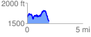
 1.981320 mi
 671.05 ft
 786.23 ft
 -115.17 ft
 7.52 %
GPX Downloads: Track Route
![]()
|
| at: |
Whissenhunt/Campbell Mountain |
show on map
animate
1.981320 mi
671.05 ft
786.23 ft
-115.17 ft
7.52 %