| at: |
Morganton Point Recreation Area |
Data from USFS GIS
 show on map
 animate
Trail users:

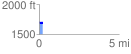
Elevation Profile
 0.212204 mi
 28.70 ft
 44.61 ft
 -15.92 ft
 3.98 %
GPX Downloads: Track Route
![]()
| at: |
Morganton Point Recreation Area |
show on map
animate
0.212204 mi
28.70 ft
44.61 ft
-15.92 ft
3.98 %