|
| at: |
Whissenhunt/Campbell Mountain |
Data from USFS GIS
 show on map
 animate
Trail users:


Elevation Profile
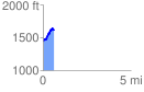
 0.620260 mi
 248.02 ft
 72.60 ft
 175.42 ft
 7.57 %
GPX Downloads: Track Route
![]()
|
| at: |
Whissenhunt/Campbell Mountain |
show on map
animate
0.620260 mi
248.02 ft
72.60 ft
175.42 ft
7.57 %