| at: |
Whissenhunt/Campbell Mountain |
Data from USFS GIS
 show on map
 animate
Trail users:


Elevation Profile
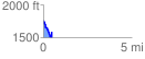
 0.486266 mi
 110.87 ft
 266.15 ft
 -155.28 ft
 10.37 %
GPX Downloads: Track Route
![]()
| at: |
Whissenhunt/Campbell Mountain |
show on map
animate
0.486266 mi
110.87 ft
266.15 ft
-155.28 ft
10.37 %