| at: |
Houston Valley |
Data from USFS GIS
 show on map
 animate
USFS GIS data shows this as an inventoried trail, named XXX.
Trail users:


Elevation Profile
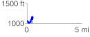
 0.563837 mi
 304.82 ft
 219.41 ft
 85.41 ft
 10.24 %
GPX Downloads: Track Route