|
| at: |
Helton Creek Area |
Data from USFS GIS
 show on map
 animate
Trail users:


Elevation Profile
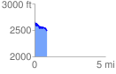
 0.876784 mi
 142.09 ft
 320.90 ft
 -178.81 ft
 6.93 %
GPX Downloads: Track Route
![]()
|
| at: |
Helton Creek Area |
show on map
animate
0.876784 mi
142.09 ft
320.90 ft
-178.81 ft
6.93 %