| at: |
Clemson Experimental Forest |
Data from Positive Flow
 show on map
 animate
Trail users:


Elevation Profile
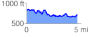
 4.716347 mi
 866.67 ft
 953.63 ft
 -86.97 ft
 3.83 %
GPX Downloads: Track Route
![]()
| at: |
Clemson Experimental Forest |
show on map
animate
4.716347 mi
866.67 ft
953.63 ft
-86.97 ft
3.83 %