| at: |
Buffalo Creek |
Data from Positive Flow
 show on map
 animate
Trail users:


Elevation Profile
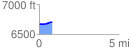
 0.812004 mi
 64.97 ft
 15.82 ft
 49.15 ft
 1.52 %
GPX Downloads: Track Route
![]()
| at: |
Buffalo Creek |
show on map
animate
0.812004 mi
64.97 ft
15.82 ft
49.15 ft
1.52 %