| at: |
Buffalo Creek |
Data from Positive Flow
 show on map
 animate
Trail users:


Elevation Profile
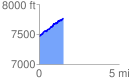
 1.527305 mi
 346.90 ft
 44.88 ft
 302.03 ft
 4.30 %
GPX Downloads: Track Route
![]()
| at: |
Buffalo Creek |
show on map
animate
1.527305 mi
346.90 ft
44.88 ft
302.03 ft
4.30 %