| at: |
Buffalo Creek |
Data from Positive Flow
 show on map
 animate
Trail users:


Elevation Profile
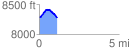
 1.132089 mi
 150.98 ft
 155.64 ft
 -4.66 ft
 2.60 %
GPX Downloads: Track Route
![]()
| at: |
Buffalo Creek |
show on map
animate
1.132089 mi
150.98 ft
155.64 ft
-4.66 ft
2.60 %