| at: |
Buffalo Creek |
Data from Positive Flow
 show on map
 animate
Trail users:


Elevation Profile
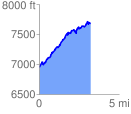
 3.233722 mi
 1087.15 ft
 352.50 ft
 734.65 ft
 6.37 %
GPX Downloads: Track Route
Trailheads:
 Shinglemill
![]()
| at: |
Buffalo Creek |
show on map
animate
3.233722 mi
1087.15 ft
352.50 ft
734.65 ft
6.37 %
Shinglemill