| at: |
Buffalo Creek |
Data from Positive Flow
 show on map
 animate
Trail users:


Elevation Profile
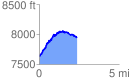
 2.400604 mi
 559.82 ft
 230.43 ft
 329.39 ft
 4.42 %
GPX Downloads: Track Route
Trailheads:
 Gashouse Gulch
![]()
| at: |
Buffalo Creek |
show on map
animate
2.400604 mi
559.82 ft
230.43 ft
329.39 ft
4.42 %
Gashouse Gulch