| at: |
Buffalo Creek |
Data from David Muse
 show on map
 animate
Trail users:


Elevation Profile
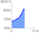
 2.720169 mi
 787.87 ft
 129.99 ft
 657.88 ft
 5.49 %
GPX Downloads: Track Route
![]()
| at: |
Buffalo Creek |
show on map
animate
2.720169 mi
787.87 ft
129.99 ft
657.88 ft
5.49 %