| at: |
Buffalo Creek |
Data from David Muse
 show on map
 animate
Trail users:


Elevation Profile
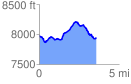
 3.559604 mi
 460.92 ft
 499.67 ft
 -38.74 ft
 2.66 %
GPX Downloads: Track Route
![]()
| at: |
Buffalo Creek |
show on map
animate
3.559604 mi
460.92 ft
499.67 ft
-38.74 ft
2.66 %