| at: |
Davidson River Area |
Data from Lush S
 show on map
 animate
Trail users:


Elevation Profile
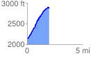
 2.032648 mi
 797.65 ft
 74.37 ft
 723.28 ft
 7.43 %
GPX Downloads: Track Route
![]()
| at: |
Davidson River Area |
show on map
animate
2.032648 mi
797.65 ft
74.37 ft
723.28 ft
7.43 %