| at: |
Davidson River Area |
Data from Lush S
 show on map
 animate
Trail users:

Elevation Profile
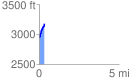
 0.345814 mi
 250.64 ft
 8.39 ft
 242.25 ft
 13.73 %
GPX Downloads: Track Route
![]()
| at: |
Davidson River Area |
show on map
animate
0.345814 mi
250.64 ft
8.39 ft
242.25 ft
13.73 %