| at: |
Ojitos Canyon |
Data from Lush S
 show on map
 animate
Trail users:


Elevation Profile
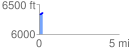
 0.240703 mi
 32.86 ft
 4.07 ft
 28.79 ft
 2.59 %
GPX Downloads: Track Route
![]()
| at: |
Ojitos Canyon |
show on map
animate
0.240703 mi
32.86 ft
4.07 ft
28.79 ft
2.59 %