| at: |
Skyline Trail Area |
Data from Jason Sager
 show on map
 animate
Trail users:


Elevation Profile
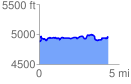
 4.342643 mi
 383.40 ft
 319.74 ft
 63.65 ft
 1.67 %
GPX Downloads: Track Route
![]()
| at: |
Skyline Trail Area |
show on map
animate
4.342643 mi
383.40 ft
319.74 ft
63.65 ft
1.67 %