| at: |
Santos |
Data from USFS GIS
 show on map
 animate
Trail users:


Elevation Profile
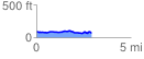
 2.953248 mi
 193.61 ft
 208.21 ft
 -14.60 ft
 1.34 %
GPX Downloads: Track Route
Trailheads:
 49th Avenue
![]()
| at: |
Santos |
show on map
animate
2.953248 mi
193.61 ft
208.21 ft
-14.60 ft
1.34 %
49th Avenue