| at: |
Santos |
Data from USFS GIS
 show on map
 animate
Trail users:


Elevation Profile
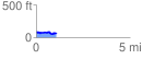
 1.086120 mi
 91.77 ft
 118.07 ft
 -26.30 ft
 2.06 %
GPX Downloads: Track Route
![]()
| at: |
Santos |
show on map
animate
1.086120 mi
91.77 ft
118.07 ft
-26.30 ft
2.06 %