| at: |
Santos |
Data from USFS GIS
 show on map
 animate
Trail users:


Elevation Profile
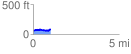
 1.016505 mi
 100.00 ft
 72.49 ft
 27.50 ft
 1.86 %
GPX Downloads: Track Route
![]()
| at: |
Santos |
show on map
animate
1.016505 mi
100.00 ft
72.49 ft
27.50 ft
1.86 %