| at: |
Santos |
Data from USFS GIS
 show on map
 animate
Trail users:


Elevation Profile
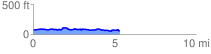
 5.434102 mi
 497.61 ft
 516.27 ft
 -18.65 ft
 1.80 %
GPX Downloads: Track Route
![]()
| at: |
Santos |
show on map
animate
5.434102 mi
497.61 ft
516.27 ft
-18.65 ft
1.80 %