| at: |
Santos |
Data from USFS GIS
 show on map
 animate
Trail users:


Elevation Profile
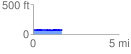
 1.697178 mi
 78.97 ft
 82.30 ft
 -3.32 ft
 0.92 %
GPX Downloads: Track Route
![]()
| at: |
Santos |
show on map
animate
1.697178 mi
78.97 ft
82.30 ft
-3.32 ft
0.92 %