| at: |
Santos |
Data from USFS GIS
 show on map
 animate
Trail users:


Elevation Profile
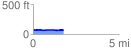
 1.783078 mi
 74.56 ft
 71.50 ft
 3.06 ft
 0.79 %
GPX Downloads: Track Route
![]()
| at: |
Santos |
show on map
animate
1.783078 mi
74.56 ft
71.50 ft
3.06 ft
0.79 %