| at: |
Santos |
Data from USFS GIS
 show on map
 animate
Trail users:


Elevation Profile
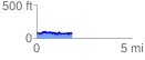
 1.907184 mi
 305.54 ft
 305.54 ft
 0.00 ft
 3.03 %
GPX Downloads: Track Route
Trailheads:
 Vortex
![]()
| at: |
Santos |
show on map
animate
1.907184 mi
305.54 ft
305.54 ft
0.00 ft
3.03 %
Vortex