| at: |
Santos |
Data from USFS GIS
 show on map
 animate
Trail users:


Elevation Profile
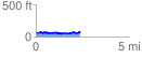
 2.420827 mi
 170.31 ft
 161.01 ft
 9.29 ft
 1.33 %
GPX Downloads: Track Route
![]()
| at: |
Santos |
show on map
animate
2.420827 mi
170.31 ft
161.01 ft
9.29 ft
1.33 %