| at: |
Kennesaw Mountain National Battlefield Park |
Data from National Parks Service
 show on map
 animate
Trail users:

Elevation Profile
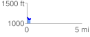
 0.349089 mi
 32.35 ft
 58.92 ft
 -26.57 ft
 3.20 %
GPX Downloads: Track Route
![]()
| at: |
Kennesaw Mountain National Battlefield Park |
show on map
animate
0.349089 mi
32.35 ft
58.92 ft
-26.57 ft
3.20 %