| at: |
Davidson River Area |
Data from Karlos Bernart
 show on map
 animate
Trail users:


Elevation Profile
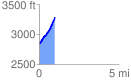
 0.982579 mi
 458.19 ft
 22.45 ft
 435.74 ft
 8.83 %
GPX Downloads: Track Route
![]()
| at: |
Davidson River Area |
show on map
animate
0.982579 mi
458.19 ft
22.45 ft
435.74 ft
8.83 %