| at: |
Bluebonnet Swamp Nature Center |
Data from David Muse
 show on map
 animate

Trail users:

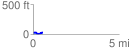
Elevation Profile
 0.565992 mi
 36.67 ft
 36.93 ft
 -0.27 ft
 1.24 %
GPX Downloads: Track Route
Trailheads:
 Bluebonnet Swamp
![]()
| at: |
Bluebonnet Swamp Nature Center |
show on map
animate
0.565992 mi
36.67 ft
36.93 ft
-0.27 ft
1.24 %
Bluebonnet Swamp