|
| at: |
Swallow Creek WMA |
Data from USFS GIS
 show on map
 animate
Trail users:


Elevation Profile
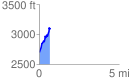
 0.688120 mi
 493.05 ft
 80.19 ft
 412.85 ft
 13.57 %
GPX Downloads: Track Route
![]()
|
| at: |
Swallow Creek WMA |
show on map
animate
0.688120 mi
493.05 ft
80.19 ft
412.85 ft
13.57 %