|
| at: |
Lake Burton WMA |
Data from David Muse
 show on map
 animate
Trail users:


Elevation Profile
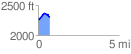
 0.715436 mi
 114.65 ft
 98.34 ft
 16.32 ft
 3.04 %
GPX Downloads: Track Route
![]()
|
| at: |
Lake Burton WMA |
show on map
animate
0.715436 mi
114.65 ft
98.34 ft
16.32 ft
3.04 %