|
| at: |
Lake Burton WMA |
Data from David Muse
 show on map
 animate
Trail users:


Elevation Profile
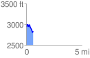
 0.618417 mi
 123.76 ft
 231.12 ft
 -107.36 ft
 7.08 %
GPX Downloads: Track Route
![]()
|
| at: |
Lake Burton WMA |
show on map
animate
0.618417 mi
123.76 ft
231.12 ft
-107.36 ft
7.08 %