| in: |
Central Florida |
near: |
Apopka,
Florida |
 show on map
 printable map
Last Trail Update: 2017-12-26
printable map
Last Trail Update: 2017-12-26There are a lot more roads and trails in this area. These are just the ones that the contributors to this site have explored so far.
Maps: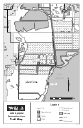
Links:
Recreation Guide to District Lands: Lake Apopka Restoration Area
Trailheads:
 Clay Island TrailheadLake Apopka TrailheadMagnolia Park
Total Mileage: (note)
 Bike/Horse Trail - 35.16 mi Dirt/Gravel Road - 0.15 mi
Trails:
Apopka-Beauclair Canal Firelane - 0.79 mi Canal Road - 3.81 mi Canal Road Connector - 1.49 mi Clay Island Firelane - 2.07 mi Clay Island Trail Loop - 5.76 mi Clay Island Trail Loop Alternate - 0.35 mi County Road 448A Spur - 0.60 mi County Road 448A Spur 2 - 1.56 mi Lake Apopka Loop Trail Alternate - 1.25 mi Lake Apopka Loop Trail (Section 1) - 4.10 mi Lake Apopka Loop Trail (Section 2) - 1.26 mi Lake Apopka Loop Trail (Unexplored) - 3.28 mi Lake Apopka Trail - 3.53 mi Lakeshore Firelane - 3.19 mi Lust Road (Apopka Preserve) - 1.99 mi Welland Road - 0.06 mi Welland Road (Unexplored) - 0.06 mi Wolfs Head - 0.94 mi Wolfs Head (Unexplored Section 1) - 0.02 mi Wolfs Head (Unexplored Section 2) - 0.04 mi Roads:
Lust Road (Unpaved) - 0.15 mi Lust Road (Paved) - 0.51 mi Magnolia Park Lot - 0.09 mi