| in: |
Pisgah National Forest |
near: |
Asheville,
North Carolina |
 show on map
 printable map
Last Trail Update: 2011-09-17
printable map
Last Trail Update: 2011-09-17Maps:
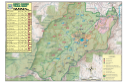
Trailheads:
 Hardtimes TrailheadLedford Parking AreaRice Pinnacle Parking Area
Total Mileage: (note)
 Hiking Trail - 0.29 mi Bike Trail - 5.15 mi Bike/Horse Trail - 9.74 mi Dirt/Gravel Road - 18.64 mi
Trails:
Homestead (Hike-Only Section) - 0.29 mi Boyd Branch - 0.63 mi Campground Connector - 0.36 mi Greens Lick - 1.93 mi Homestead (Hike-Bike Section) - 0.42 mi Ingles Field Gap (Hike-Bike Section) - 0.52 mi Wolf Branch - 1.29 mi Deer Lake Lodge (Section 1) - 0.96 mi Deer Lake Lodge (Section 2, Unexplored) - 0.03 mi Ingles Field Connector - 0.35 mi Ingles Field Gap (Hike-Bike-Horse Section) - 1.24 mi Little Hickory Top - 1.19 mi Lower Sidehill (East Side) - 0.65 mi Lower Sidehill (West Side) - 1.64 mi Sidehill Connector - 0.38 mi Sidehill (East Side) - 1.25 mi Sidehill (West Side) - 2.07 mi Roads:
Bent Creek Gap Road (Unpaved) - 0.91 mi Deer Lake Lodge Road - 0.38 mi East Powhatan Camping Loop Connector - 0.22 mi FS479E - 2.08 mi | AKA: |
Ledford Branch Road |
FS479F - 0.92 mi | AKA: |
Boyd Branch Road |
FS479G - 0.94 mi FS479M - 5.44 mi FS485 - 4.82 mi | AKA: |
North Boundary Road |
FS491 - 1.72 mi Hardtimes Road - 1.14 mi Hardtimes Road Connector - 0.05 mi Hardtimes Road (Unexplored) - 0.03 mi Bent Creek Gap Road (Paved) - 4.74 mi Deer Lake Lodge Trailhead Road - 0.18 mi Lake Powhatan Recreation Area Road - 0.82 mi Ledford Parking Area - 0.04 mi Old Hardtimes Road - 0.43 mi Wesley Branch Road - 2.24 mi