| at: |
Blue Ridge WMA Bull/Jake Mountain |
Data from David Muse
 show on map
 animate
Trail users:


Elevation Profile
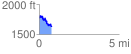
 0.778624 mi
 106.91 ft
 268.10 ft
 -161.20 ft
 6.52 %
GPX Downloads: Track Route
Trailheads:
 Jake Mountain Parking Lot