| at: |
Tannehill Ironworks Historical State Park |
Data from Positive Flow
 show on map
 animate
Trail users:


Elevation Profile
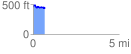
 0.805418 mi
 68.23 ft
 95.09 ft
 -26.86 ft
 2.24 %
GPX Downloads: Track Route
![]()
| at: |
Tannehill Ironworks Historical State Park |
show on map
animate
0.805418 mi
68.23 ft
95.09 ft
-26.86 ft
2.24 %