|
| at: |
Warwoman WMA |
Data from David Muse
 show on map
 animate
This trail is labeled 155E on the map distributed by the forest service, but 155A in their GIS data.
Trail users:


Elevation Profile
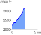
 2.504547 mi
 1209.85 ft
 291.90 ft
 917.94 ft
 9.15 %
GPX Downloads: Track Route