| at: |
Sabine National Forest |
Data from USFS GIS
 show on map
 animate
Trail users:


Elevation Profile
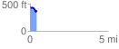
 0.439562 mi
 38.94 ft
 102.35 ft
 -63.41 ft
 4.41 %
GPX Downloads: Track Route
![]()
| at: |
Sabine National Forest |
show on map
animate
0.439562 mi
38.94 ft
102.35 ft
-63.41 ft
4.41 %