|
| at: |
Blue Ridge WMA |
Data from David Muse
 show on map
 animate
Trail users:


Elevation Profile
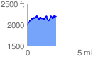
 2.525870 mi
 673.10 ft
 478.86 ft
 194.24 ft
 5.05 %
GPX Downloads: Track Route
![]()
|
| at: |
Blue Ridge WMA |
show on map
animate
2.525870 mi
673.10 ft
478.86 ft
194.24 ft
5.05 %