|
| at: |
West Georgia Pinhoti Johns Mountain WMA Dry Creek |
Data from USFS GIS
 show on map
 animate
Trail users:


Elevation Profile
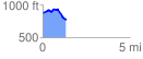
 1.317896 mi
 127.77 ft
 213.90 ft
 -86.13 ft
 3.07 %
GPX Downloads: Track Route
![]()
|
| at: |
West Georgia Pinhoti Johns Mountain WMA Dry Creek |
show on map
animate
1.317896 mi
127.77 ft
213.90 ft
-86.13 ft
3.07 %