|
| at: |
West Georgia Pinhoti Trans North Georgia Johns Mountain WMA |
Data from USFS GIS
 show on map
 animate
Trail users:


Elevation Profile
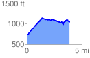
 3.920462 mi
 770.14 ft
 453.67 ft
 316.47 ft
 3.72 %
GPX Downloads: Track Route
![]()
|
| at: |
West Georgia Pinhoti Trans North Georgia Johns Mountain WMA |
show on map
animate
3.920462 mi
770.14 ft
453.67 ft
316.47 ft
3.72 %