|
| at: |
West Georgia Pinhoti Trans North Georgia Johns Mountain WMA |
Data from USFS GIS
 show on map
 animate
Trail users:


Elevation Profile
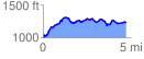
 4.761439 mi
 854.36 ft
 638.54 ft
 215.82 ft
 3.40 %
GPX Downloads: Track Route
![]()
|
| at: |
West Georgia Pinhoti Trans North Georgia Johns Mountain WMA |
show on map
animate
4.761439 mi
854.36 ft
638.54 ft
215.82 ft
3.40 %