| at: |
West Georgia Pinhoti Trans North Georgia Johns Mountain WMA |
Data from David Muse
 show on map
 animate
Trail users:


Elevation Profile
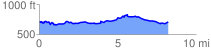
 8.340536 mi
 654.71 ft
 691.19 ft
 -36.47 ft
 1.57 %
GPX Downloads: Track Route
Trailheads:
 Pinhoti - Simms Mountain