| at: |
Chestatee WMA |
Data from David Muse
 show on map
 animate
Trail users:


Elevation Profile
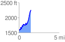
 1.492053 mi
 858.60 ft
 182.83 ft
 675.77 ft
 10.90 %
GPX Downloads: Track Route
![]()
| at: |
Chestatee WMA |
show on map
animate
1.492053 mi
858.60 ft
182.83 ft
675.77 ft
10.90 %