|
| at: |
Sumter National Forest - Long Cane District |
Data from USFS GIS
 show on map
 animate
Trail users:


Elevation Profile
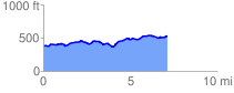
 7.206959 mi
 496.75 ft
 345.55 ft
 151.20 ft
 1.31 %
GPX Downloads: Track Route
![]()
|
| at: |
Sumter National Forest - Long Cane District |
show on map
animate
7.206959 mi
496.75 ft
345.55 ft
151.20 ft
1.31 %