| at: |
Sumter National Forest - Long Cane District |
Data from USFS GIS
 show on map
 animate
Trail users:


Elevation Profile
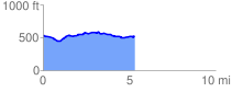
 5.493097 mi
 261.00 ft
 267.59 ft
 -6.58 ft
 0.92 %
GPX Downloads: Track Route
![]()
| at: |
Sumter National Forest - Long Cane District |
show on map
animate
5.493097 mi
261.00 ft
267.59 ft
-6.58 ft
0.92 %