|
| at: |
Sumter National Forest - Long Cane District |
Data from USFS GIS
 show on map
 animate
Trail users:


Elevation Profile
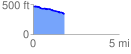
 1.805970 mi
 24.45 ft
 151.27 ft
 -126.82 ft
 1.59 %
GPX Downloads: Track Route
![]()
|
| at: |
Sumter National Forest - Long Cane District |
show on map
animate
1.805970 mi
24.45 ft
151.27 ft
-126.82 ft
1.59 %