|
| at: |
Sumter National Forest - Long Cane District |
Data from USFS GIS
 show on map
 animate
Trail users:


Elevation Profile
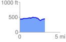
 3.104609 mi
 143.46 ft
 145.85 ft
 -2.40 ft
 0.89 %
GPX Downloads: Track Route
![]()
|
| at: |
Sumter National Forest - Long Cane District |
show on map
animate
3.104609 mi
143.46 ft
145.85 ft
-2.40 ft
0.89 %