|
| at: |
Sumter National Forest - Long Cane District Cedar Springs OHV Trail |
Data from USFS GIS
 show on map
 animate
Trail users:


Elevation Profile
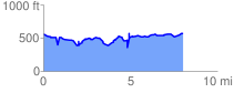
 8.017134 mi
 1500.37 ft
 1471.75 ft
 28.62 ft
 3.54 %
GPX Downloads: Track Route