| at: |
Sumter National Forest - Long Cane District |
Data from USFS GIS
 show on map
 animate
Trail users:


Elevation Profile
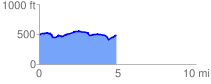
 5.151728 mi
 338.99 ft
 339.26 ft
 -0.27 ft
 1.25 %
GPX Downloads: Track Route
![]()
| at: |
Sumter National Forest - Long Cane District |
show on map
animate
5.151728 mi
338.99 ft
339.26 ft
-0.27 ft
1.25 %